
Alto Technology Resources (http://www.altotechnology.com/marfa/index.htm)
Hyperspectral Analysis of the Marfa Lights Alto Technology Resources is in the business of providing airborne sensor and satellite analysis of various terrain covers throughout the world. Normally, but not always, this is done on a proprietary basis. However, in August and September of 2000 our airborne sensor flew a number of places in West Texas, one of which was within a short distance from Marfa, Texas home of the mysterious lights. At our behest, the flight crew acquired daytime and nighttime hyperspectral data over an area from Marfa in the north to approximately Lake San Esteban in the south. Furthermore, we were allowed to present our findings to the public on these fascinating lights.
A ground observer was stationed at the Marfa Mystery Light Observation Site while the aircraft was acquiring data. He saw the Marfa Lights in action and recorded them as well as conversations with the pilots on a conventional camcorder. Exact positions were known from onboard GPS units. The following is a summary of our findings:
1. While the ground observer saw Marfa Light activity, the pilots overhead saw nothing. They saw only known light sources from the town of Marfa, isolated cars on the roadways, a weigh station (or other permanent building along Hwy 67), and the radio beacons.
2. Nighttime sensor thermal infrared data confirmed the pilots' observations. While the sensor was capable of discriminating among soil types, soil conditions, lights, vegetation and roadways, no anomalies were detected. This lack of data effectively rules out ball lightening/plasma, burning swamp gas, radiant gas, pranksters carrying flashlights or lanterns, or direct car headlight beams.
3. Daytime sensor data showed the presence of areas with highly reflective soil in the extreme southwestern portion of the study area. Much of this soil flanked Highway 67 descending from the Chinati Mountains.
4. We combined the computer-generated soil distribution with the US Geological Survey topographic maps and Digital Elevation Models (DEM) that allowed us to view the soils and the topography as they would be seen from the Marfa Lights Observation Site.
From our analysis, we believe that car headlights shining in the direction of the Observation Site, reflected along the concave surface of soil alongside of Highway 67 are the source of the Lights. The highly reflective soil acts as a mirrored surface that creates the observed phenomena. Although we do not have all the answers, those interested in seeing a more detailed description of the project with figures and maps can proceed by clicking here. Visitors may also use the "nav buttons" (arrow and home icons) at the top of this and the ensuing pages to move through the report in sequence. Alternatively, the table of contents at left is hyperlinked and may be used to view the findings in any order. Comments and questions about this project may be directed to janksjs@altotechnology.com.
Introduction:
Alto Technology Resources acquired hyperspectral data of portions of West Texas and New Mexico in July-September, 2000 for the purpose of establishing environmental baselines and soil and vegetation types in the region. One of these projects was geographically close to Marfa, TX, south of where The Marfa Mystery Lights reportedly exist. Because little new data have been added to the body of knowledge about the phenomena, we decided to perform a daytime-nighttime hyperspectral analysis of the area and make our findings available to the public. This report presents our findings, observations from the pilots and flight crew, and a hypothesis for the Lights' occurrence. Our findings do not answer all the questions, but they do provide a data basis for future discussions.
The famous "Marfa Mystery Lights" have been the subject of controversy and speculation for decades. They appear almost nightly south and southwest of Marfa and are known to move, divide and merge, and flicker brilliantly. The Lights are so well-known that the Texas State Highway Department erected a sign and viewing area along Highway 67/90 east of Marfa. They have been included in at least three TV documentaries, and some studies have been conducted under the auspices of local universities. James Dean viewed the spectacle while filming the movie Giant (filmed in Marfa). When the Lights first appeared remains somewhat clouded. Local lore claims that they have existed at least from the late 19th Century, but there appears to be little documentation of this. They have been attributed at various times to ball lightening, burning swamp gas, radiant gasses released along fault lines, pranksters running around with flashlights and lanterns, and car headlights. To date no one has been observed with flashlights and/or lanterns. Others have scoffed at the idea that the lights are anything more than headlights, and claim proof using high-powered binoculars. This latter group is at a loss, however, to explain why there are often more Lights than there are cars, or why the Lights merge, divide and disappear. There are a number of "Marfa Mystery Lights" websites available to those interested in pursuing the topic.
Experimental Design:
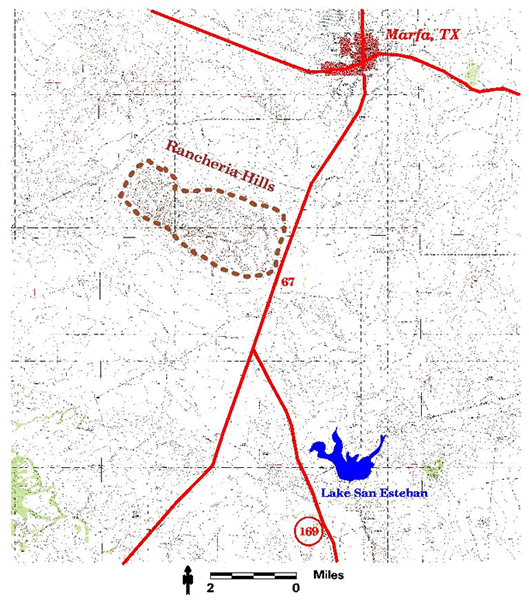
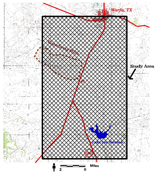
Marfa, Texas is located in the desert Southwest, west of Alpine, Texas. Highway 67 runs approximately north-south through Marfa, but gradually veers to the southwest a few miles south (Big Figure 1).
Most of the topography is flat and sparsely vegetated, however the Chinati Mountains rise in the distance to the south. Our goal was to determine if the Lights appeared south and southwest of the Marfa Light Observation Site. It is nearly impossible to determine the distance that the Lights are from the viewer. We estimated that south of Lake San Esteban would be sufficient to detect any Lights. The pilots, at 3,500 ft had a much more expansive field of vision, capable of seeing tens of miles in all directions. A daytime and nighttime acquisition over the area of interest was gathered on August 25, 2000 (Big Figure 2). 
Precise position is known at all times using on-board GPS information; the position of the aircraft over the earth is known with absolute certainty. Additionally, a ground observer at the "Marfa Mystery Lights" Observation Area recorded their appearance that evening and measured the azimuth where the lights were observed. The aircraft flew at 3,500 feet and gathered information at pixel sizes of <2 meters. Time and cost constraints limited the aerial extent of survey, and we were not able to fly all the way to the Chinatis. Data acquisition ranged from the Ultraviolet (0.3 mm) to the Thermal Infrared (12.5 mm). This was done to ensure that any reflection or emission other than in the visible portion of the electromagnetic spectrum (0.4 to 0.7 mm) would be evaluated . We included both night and daytime surveys. Our ground observer recorded the events on a conventional camcorder, so that the Lights' activities were documented during the flight. Although the quality of this video is only amateur, conversations between the pilots and the ground observer were recorded. A portion of this video, for those interested, is coming soon.
Results of the Nighttime Survey:
A ground observer stationed at the Marfa Mystery Light Observation Area recorded Marfa Lights as they appeared on August 25, 2000. He and the pilots discussed the Lights' location several times, as there appeared to be confusion about the location of the Lights. The pilots did not observe any discrete lights within their field of view, which extended to the Chinati Mountains during the entire 1 1/2 hour flight. The only lights observed were an occasional car along Highway 67 coming from the Chinatis, a radio tower with a few cars (not moving) and a weigh station. These latter features were also seen on the daytime images. The ground observer, on the other hand, described the location of the Lights relative to the aircraft, including the azimuths of their appearance. The nighttime data analysis included the thermal infrared portion of the electromagnetic spectrum. No lights were seen on the data, except the radio beacon, a few cars and the town of Marfa itself. Thermal infrared imagery, which measures small changes in temperature due to ground cover type (buildings, roads, plants, etc.), moisture content, even soil chemistry, detected nothing above the background levels of the terrain. Distinct soil types, based upon moisture levels and chemical makeup are separated based upon their thermal inertia, i.e. the measure of the thermal response of a material to temperature change. Each soil type responds slightly differently in the thermal channels. Water bodies, which are mostly shallow stock tanks or ponds here, are also distinctive. No unidentified light sources were seen in the area south of Marfa, a fact corroborated by the pilots' observations. The ground observer, stationed at the Marfa Light Observation point, identified that the Lights appeared from azimuths 220° to 245°. The first ones appeared at 220°. The entire range of possible locations is shown in Figure 3

. Figure 3: Nighttime thermal data over the southwestern portion of the study area. Highway 67 appears as a black line running from the lower left to the upper right. Warmer objects appear white to light gray and darker ones gray to black. Several distinct soil types are identified solely by their thermal response (red arrows). A blue arrow points to a small pond or stock tank.
Our ground observer found it nearly impossible to make an accurate assessment of the distance that separated him from the Lights. This uncertainty regarding distance has been noted in many of the stories about the Lights. Some individuals have even claimed that the Lights approached so close that the individuals felt compelled to leave (one of these individuals can be heard at the end of the VCR recording).
Daytime Survey:
Most of the Marfa area under study was unremarkable desert soil, with sparse vegetation. The soils were composed of sand, gravel and clays with varying moisture contents and chemical composition. There was a mixture of ferrous and ferric iron (which produces a red color). The sensor, however, also detected a highly reflective white soil that was found mostly in the southwestern quarter of the study area. A large concentration was found in the far southwestern section, forming along mesas that flanked Highway 67, and some nearby dunes. These areas are shown in Figure 4. 
This soil reflects almost all wavelengths. The white soil reflects significantly more energy than surrounding soil types, and is displayed here in the visible portion of the spectrum. This reflective soil has heretofore gone without comment (or notice) in most of the websites and documentaries. We believe that this reflective soil is a major player in the creation of the Marfa Lights. We used computer analysis to generate a map of this soil's distribution in the study area. A detailed portion of that map is shown in Figure 5. 
The right side image shows the reflective soil in green. These data criteria were then applied to the entire image.
Discussion:
The Marfa Lights have heretofore mostly defied conventional explanations, because there are major inconsistencies in the hypotheses presented thus far. The Lights were not seen from above, by either the pilots or our hyperspectral sensor, yet they were clearly seen by our ground observer. The absence of thermal anomalies indicates that there was nothing on the ground, such as a sphere of ball lightening or a cloud of burning gas, to generate such a signal. We can therefore eliminate any discrete source of light and/or heat:
1.Ball Lightening/plasma
2.Radiant gasses
3.Burning swamp gas
4.Pranksters with lanterns or flashlights
5.Direct car headlight beams
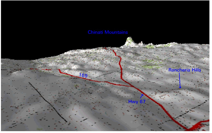
Some skeptics have viewed the Lights with binoculars and stated that they are car headlights. Others, including the documentaries, have countered that there are often more Lights than cars, and that the cars' lights would not divide and merge as seen with the Lights. Indeed, many deserts worldwide have roads that cars use all the time and to our knowledge none has a phenomenon like the Marfa Lights. To examine what could create the Marfa Lights, we employed the computer-generated reflective soil map with Digital Elevation Models (DEM) and the US Geological Survey Topographic (often shortened to "topo") maps (formed into a mosaic). A DEM-map combination allows the user to move within the boundaries of the data and view the image from different angles, elevations and perspectives. In most cases we exaggerate the vertical component by 10 to 25 times, for easier viewing of the 3-D map. If an observer were located to the northeast of Marfa, looking southwest (along azimuth 220°) he would see the Rancheria Hills and the Chinati Mountains rising in the distance and mostly flat plain elsewhere (Figure 6). 
Figure shows: USGS topo sheet draped over a Digital Elevation Model (DEM). Vertical Exaggeration: 10x. This view, just east of Marfa (seen at the lower right corner) looks to the southwest. In that position, Highway 67 can be seen descending from the Chinati Mountains.
Figure 6 places the observer on a segment of Highway 67 & 90, which runs east-west, and along which the Observation Site is located. Highway 67 can be seen emerging from the Chinati Mountains in the distance. Road 169 is seen splitting from Highway 67 and going southeast.

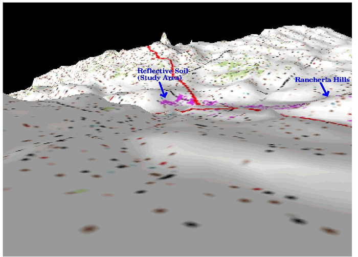
Figure shows: The distribution of reflective soil in the study area (purple) and the USGS topo sheet has been draped over a DEM at 10x vertical exaggeration. This view is from the northeast, and shows Highway 67 traveling southwest while Road 169 splits off and travels to the southeast. The topography has been digitally smoothed. The large 'bump' at lower right center is the Rancheria Hills. Figure 7 is a view from the air, but includes the distribution of reflective soil (purple) as well as the DEM and the USGS topo sheet (soil shown in purple). Almost all of the reflective soil is found in the southwestern portion of the study area. However, the perspective of an observer on the ground changes the visible distribution of the reflective soil relative to his field of view. The perspective of the viewer from the Observation Site would be seen in Figure 8. 
Figure shows: Zoomed in view of Highway 67 splitting off to the southwest from Road 169. The distribution of reflective soil, shown in purple, is predominantly in the southwestern portion of the study area. The large bump at right center is the Rancheria Hills. Highway 67 can be seen descending from the Chinati Mountains. 10x.
From the Observation Area, portions of this soil are seen only in the region from 220°, where they are found parallel to Highway 67, to just south of the Rancheria Hills at 245°. A car descending from the Chinati Mountains would begin shining its headlights in the direction of the observer several miles to the southwest before turning northward toward Marfa. While the headlights are facing the observer, they are in alignment with the highly reflective soil that flanks the road. There are several locations where a car changes angle and the area of reflective soil is sufficiently wide to be seen by the observer. There are several small hills to the east of the Rancheria Hills that will interfere with reflected light. The Rancheria Hills themselves will stop much of the reflection to someone in Marfa. The reflectivity on the north side of the Rancheria Hills may provide additional lights to someone standing west of Marfa and looking down along Mitchell Flats, however we did not have a ground observer at that location. We believe that the reflective soil, deposited along the concave surface of the flanks of the Chinati Mountains, acts as a giant reflecting surface to cast the car headlight beams in the direction of the observer at the Official Observation Site. Unfortunately, we were unable to acquire data all the way to the Chinati Mountains. Nevertheless, it is likely that the reflective surface created by the soil found on both sides of Highway 67 as it descends to the plains forms a concave surface that focuses and concentrates the headlight beams. Light generated in such a manner can appear more intense and can be split into several distinct beams as well. You can observe this phenomenon using a small household flashlight and a curved facial mirror (see below).
From these data, we conclude that the Marfa Lights are not burning or radiant gasses, nor pranksters with lanterns or flashlights, but instead they are in part due to car headlights and:
1.Topography (Chinati Mountains, Rancheria Hills)
2.Points of observation (The Marfa Lights Observation Area)
3.Highly reflective soil, distributed in only a portion of the viewing area
4.A concave surface along which vehicles pass (and shine their headlights forward at night).
We believe that the Marfa Lights are phenomena that are created by cars descending from the Chinati Mountains. As the cars descend along Highway 67, their headlights, shining northeast along the approximate azimuth of 220°, encounter the concave surface of the land that contains a coating of highly reflective soil. The soil creates a reflected beam that appears magnified and can appear to split and merge to an observer at the Marfa Lights Observation Site. This duplication, splitting and merging is likely the result of the cars' movements along the highway. At some point, the car is completely on the plain and no longer reflects its lights in the direction of the observer. Furthermore, the Rancheria Hills and other topographic features begin to block light transmission at that point.
Unanswered Questions:
There are still several unanswered questions.
First and foremost, our hypothesis has not been tested. Ours is simply a first pass at interpreting a new data set, and we strove to include our findings in the model. Verification will be required by ground observation evidence.
Second, there are numerous stories that the Lights first appeared in the latter 19th Century, a time before cars were invented. While none of these stories have been verified, if true, they would require a modification of our hypothesis.