
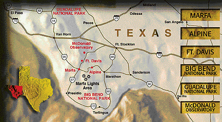
The above image is an illustration from the web page of Steve Laroche (marfaL7.htm) who is an outspoken advocate for the lights as car lights. It shows Goat Mountain to the southeast of the observing area. The origin of this map is unknown, but it looks like a commercial product, possibly from the Marfa Chamber of Commerce.

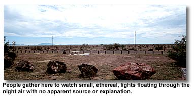
The above image is from Steve LaRoche's page. The fence of the Old Air Field is in the foreground, so the view is looking southwest. The mountain is probably Chinati. Another source notes "... The lights appear in an area SW of Chinati Mountain, on Mitchell Flat, near Twin Peaks, and over the flat prairie north of Cuesto Del Burro Mountains.. On a nice evening, dozens of people will stop and view the Lights at the "official" viewing area, about 10 miles east of town on Highway 90. (http://www.crystalinks.com/lightballs.html
This is a map (above) from a commercial business web site that describes stores in Marfa (http://www.christophers.net/_private/marfa.htm) which shows a different location for the Lights to the east of Highway 67, and directly south of the Viewing Area...closer to Goat Mountain and definitely not towards Cienega Mountain which is to the west of 67.
This image is from Bob Katz's page http://www.desertusa.com/Cities/tx/marfa.html) It is unclear what the view is. It looks like some one was standing north of the highway looking back across Highway 90 to the west, just on the other side of the 2-3 foot pole fence. The flat topped mountain to the distant left looks like it could be Goat Mountain.
I can purchase USGS topographical maps at the Dept of the Interior 'Map Store' located in the E-street entrance between 18th and 19th street. The maps cost 4-8 dollars depending on the resolution.
1...Mountains in the Horizon
.This has been, and continues to be, a challenging activity. I have only a few photographs taken near sunset (eg LaRoches) to see what the horizon looks like, and a tourist map to go by as hard evidence, plus a few accounts that bother to give geographic information.
I pieced together a topographical map from the MapQust images. My mosaic covers about a 40 x 40 mile square area. My main goal is, first of all, to identify the horizon features seen in some of the photos I have collected on the web. LaRoche's photo above, in particular. Very roughly, the horizon slopes upwards gently from the east to the west in this view looking south. There is a minor peak, followed by a major peak further to the west which has a plateau about half the peak height to the west of the peak. There are probably several foreground hills in the way that may combine to give this kind of 'integrated' horizon. Since I don't know the exact direction of view, I will have to make an educated guess based on what I see in my topographical map.
[January 23, 2001] There are two prominent mountain peaks in the map which are at approximately equal distances from the airfield. The first of these is Cienega Mountain with an elevation of 5225 feet (MapQuest). The elevation of the Viewing Area is 4903 feet, so this mountain peak sits a modest 322 feet above the Viewing Area. If we divide this by 2 and subtract from the peak height, the contour at 5225 - 161= 5064 feet represents the contour of the FWHM. From the Topo map, this contour has a width of about 0.5 miles but it has an irregular shape. To the east of this peak and behind the UTRAO installation, the landscape contains a number of features. One of these is due west of Cienega Mountain. This peak is San Jacinto Mountain with an elevation of 5082 feet and it stands 5082-4903 = 179 feet above the Visitor Center and has a FWHM contour of 5082 - 90 = 4992 feet. This contour has a diameter of only 1/4 mile, and its apparent peak would be about 1/2 as tall as Cienega Mountain. Also, San Jacinto is relatively isolated and would appear to sit near the western edge of a sloping ridgeline made up of a number of separate elements projected against the horizon line. Are these, in fact, the two peaks and the ridgeline that is seen in LaRoche's photo? I don't think so. Mount Chinati stands a full 7726 feet in elevation; a whopping 2823 feet above the Visitor Center. It is at a distance of 42.3 miles making it 3 times farther away than Cienega Mountain, and so its apparent height would be 1/3 of 2823 or about 940 feet. Cienega and Chinati would make a good match to the photograph, especially with Highway 67 passing between them. From the perspective of the Visitor Center, the cars would be heading toward the observer, closer to Mount Chinati. San Jacinto and Chinati are the prominent horizon peaks framing the Lights area as seen from the Viewing Area. LaRoches's map in Item 2.2 clearly shows where Mount San Jacinto is located. I don't know what the provenance of the map is, looks like a brochure perhaps from Marfa. The marked area for the Lights is to the west of Mount Cienega, and to the east of Mount Chinati, so again that matches what I surmised above in terms of what the two peaks are in LaRoches's photo.
[January 28 2001]. The above discussion is not right. From the photograph above, if you assume that the tall peak is Mount Cienega standing 2823 feet above the VA, or [7726 - 4600] = 3126 feet above the distant plane (not allowing for earth curvature) at 42.3 miles, this angle should be [3126/42.3 x 5280]x 206265 = 0.8 degrees. From LaRoches photo, the secondary peak to the east is about 10 times the apparent Cienega Peak height, or 8.0 degrees. At 42.3 miles, this angular distance is equal to 42.3 sin(8) = 5.9 miles. On the topo map, if you go 5.9 miles to the east of Cienega Peak, you are still on the ridge line of the Cienega Mountains, and in particular, you are near a 6408 foot, unnamed peak to the north of Presa Rincon. I will call it, for now, the Rincon Peak. Also directly on this line of sight with the kink in the roadway is a feature called 'La Mesa' which sits at an elevation of 5409 feet.
On my big mosaic map, if I draw two lines from the Viewing Area to these two peaks, (Rincon and Chinati) the eastern line passes across the kink in Highway 67 at 22 miles, which starts at an elevation near 4900 feet and slopes down to an elevation of 4700 feet within only a bit less than 1 mile. Projected against the ridgline between Chinati and the Rincon, this portion of the Highway would be 1/4 of the way to Chinati Peak. This doesnt look quite right based on LaRoches photo which seems to show lights closer to the supposed Rincon Peak than this. The tourist map above shows the lights are to the west of Cienega Peak, which would put them to the far left in LaRoches photo based on my identification of Rincon Peak. There are no clear comments about where the Lights actually appear from any of the photos especially with respect to the background mountains.
I still think I have to work on this aspect more.
[February 11, 2001]. After having done extensive background work to identify the overall topic and its history...along with historical and technical loose ends...I now return to basic geography to confirm the landmarks on maps and extant photos. Here are the geographic details mentioned in various eye-witness reports summarized:
Near Marfa;
A...On the flats east of Marfa at Paisano Pass.
D... toward Chinati Peak
E... area looking across toward the Chinati Mountains
G... distant bright lights on the Mitchell Flats
H... On the west side of Goat Mountain, in the middle of the Mitchell Flats
I... most frequently seen near the Chinati Mountains from Highway 90
J... view toward the southwest showed that parts of distant Highway 67, which runs between Marfa and Presidio could clearly be seen through the telescopes.
L... SW of Chinati Mountain, on Mitchell Flat, near Twin Peaks, and over the flat prairie north of Cuesta Del Burro Mountains
M... They appear anywhere from a degree or less above the horizon to several degrees -- the top of the Chinati Mountains, to the southeast of the viewing site. None was ever higher than the ridge line of the mountain range
N... hues to the east of the Chinati Mountains
O... , just west of the Border Patrol's red signal tower.
P... instructed to look for a lighted tower and that any lights to the right (west) of that tower would be the mystery lights
Q... . I was on the state highway east of Marfa, as was Long. And the view was the same, looking south across a basically flat plain to a range of low mountains many miles away
R... they were exactly on the horizon. Each light was white, like a headlight seen from many miles away. But they didn't move
Other Areas:
C... sighted from Twin Peaks near Alpine, across to the old mountains near Presidio
B... roam the Chinati or the Dead Horse
K... Some people have seen them north of the highway, but mostly they appear near a mountain called Twin Peaks
Now I need to get a map of the region and annotate it.
The places I have found on the MapQuest Topo maps are
1) Goat Mountain
2) Paisano Pass
3) Chinati Peak
4) Cuesta Del Burro Mountains
5) Mitchell Flats is an amorphous region to identify. 'H' says that they are located on the west-side of Goat Mountain. From the Viewing Area they are the 'distant bright lights on Mitchell Flats. The Mitchell estate sold acerage to create the Old Air Field.
Original Geographic Accounts:
"One hundred years after Ellison's time, the Houston Chronicle's Stan Redding and photographer Carlos Antonio Rios came upon the lights dancing in the high blackbrush flats east of Marfa at Paisano Pass....The lights roam the Chinati or the Dead Horse, sometimes descending to flirt about the great expanse of flats below. They range far and wide. They have been sighted from Twin Peaks near Alpine, across to the old mountains near Presidio.". William Edward Syers 'Ghost Stories of Texas' (1981)
3...They appear to be above ground level because the far side of the enormous valley swells up toward Chinati peak. They either stand still or move left to right consistent with stretches where cars come straight toward you or turn a little northward to Marfa. They disappear in a manner consistent with obstructions and turns of the road." (http://www.big.bend.national-park.com/wwwboard/messages/395.html Posted by Paul K, October 3, 2000 'Response from a Skeptic' 395.htm )
9..." From the viewing area looking across toward the Chinati Mountains there is a red beacon light and beyond that a stretch of highway running from Presidio. Some of what people see in that portion of the horizon could be car lights. But again the carlight theory runs into problems because the highway is over 40 miles away and the mystery lights were reported here long before cars existed." (marfaL4.html)
14... The lights can be seen in the southwest, across the Mitchell Flats near Chinati Mountain, from an official viewing point on Highway 90 between Alpine and Marfa. They have even been reported between Paso Lajitas and San Carlos, Mexico, and the Federales, who patrol the road for smugglers, have been fooled into spotting what they thought were approaching headlights, only to have no vehicle ever appear." (http://www.theoutlaws.com/marfa.htm marfaL8.html )
15... They appear as distant bright lights on the Mitchell Flats and are distinguishable from ranch lights and automobile headlights on nearby Highway 67, between Marfa and Presidio, by their aberrant movements and behavior. (http://www.theoutlaws.com/marfa.htm marfaL8.htm)
16...Witt's group was positively unable to form any sort of solid conclusion. They did say, however, that sometimes the lights that people claimed were "Marfa Lights," were really artificial lights from area ranches or automobile headlights merely passing behind unseen obstructions along distant Highway 67, which winds through the Chinati Mountains between Marfa and Presidio. " (http://www.theoutlaws.com/marfa.htm marfaL8.html)
18... . They were on the west side of Goat Mountain, in the middle of the Mitchell Flats. Black says it best, "Anyone who knows the Marfa flats, knows that it is flat, featureless, and boring---no geological marker out in the sea of desert and really no way to find your way around, especially in the dark(http://www.theoutlaws.com/marfa.htm marfaL8.html)
19... . Since the lights are most frequently seen near the Chinati Mountains from Highway 90, which runs east and west between Marfa and Alpine, the scientists decided they had best rule out any misidentification of headlights on Highway 67, which winds through the Chinati Mountains north and south between Marfa and Presidio(http://www.theoutlaws.com/marfa.htm marfaL8.html)
21..."We arrived at the viewing sight well before sunset, and set up a pair of 14x70 Fujinon binoculars, a 60mm. Bushnell Spacemaster with a 22 power wide field eyepiece, and Sue's custom 4.3 in. APO refractor. A careful inspection of the view toward the southwest showed that parts of distant Highway 67, which runs between Marfa and Presidio could clearly be seen through the telescopes. Cars traveling along the road would be visible for seconds to minutes, and then vanish around a curve or in a dip in the road. As the Texas landscape darkened the cars vanished and were replaced by moving lights, red or white, flickering in and out of view. With the naked eye, they did look rather strange, but the telescopes revealed the paired headlights and taillights of cars. While we were there, people arrived to look for the lights. Most quickly spotted the car lights along Route 67, exclaiming, ``There they are!'' (http://www.rensselaer.edu/~sofkam/isuny/Journal/vol1_1.html skeptics3.htm ca 1987 Alan French)
23... "Get there about 10 minutes before complete darkness. They're most active then. Look south. Some people have seen them north of the highway, but mostly they appear near a mountain called 'Twin Peaks.' That mountain kinda looks like Dolly Parton, if you know what I mean.'' (http://www.vaportrails.com/USA/USAFeatures/Marfa/Marfa.html George Ridge. 'Have ypu seen the marfa lights?)
27...... The lights appear in an area SW of Chinati Mountain, on Mitchell Flat, near Twin Peaks, and over the flat prairie north of Cuesto Del Burro Mountains.. A roadside plaque on US 90, 8 miles E of Marfa commemorates the lights. An abandoned USAF base is nearby... (http://www.crystalinks.com/lightballs.html
28... I set up my telescope at the recommended place about sundown, and a few minutes later we saw the first one. If I hadn't had the telescope, if I'd only had binoculars or unaided eye, I would have called them car headlights, nothing more or less. They vary in brightness from headlights seen a couple of miles away to a few blocks away. They appear anywhere from a degree or less above the horizon to several degrees -- the top of the Chinati Mountains, to the southeast of the viewing site. None was ever higher than the ridge line of the mountain range, which would have been interesting. So they could have been just headlights of cars on mountain roads. But in the telescope, at 70X and 140X, they don't appear double; they're round blobs of headlight-colored light... Through the telescope I could see hints of extremely faint ones that were headed in the opposite direction, as red as taillights. But even the brightest lights, under the highest magnification, showed no hint of being two lights close together, and they definitely _would_ if I were just looking at headlights a certain distance away. (http://www.sff.net/people/sfreader/biketrip.html April 6, 1998. Joe and Gay Haldeman )
36... Since that time, people have flocked to what is now Route 90, nine miles east of Marfa, to try to spot the lights, which have appeared in white, pink, yellow, green, and blue hues to the east of the Chinati Mountains. (Texas Monthly... http://www.texasmonthly.com/ranch/ufo/marfa.html)
37... It is located about 8 miles east of Marfa at a high point that gives a clear view of the area where the Marfa Lights are seen... generally looking off to the south at something that looked car headlights along the side of a mountain range that was about 15 miles away. ...In the binoculars it was clear that these lights were not pin point car headlights but were small glowing disks (or spheres) of light that were a bright yellow orange in color. ...At times there were as many as a dozen lights visible at one time and the east to west extent of the area was perhaps 5 miles. (Charlie Miller October 1996, http://homepage.psy.utexas.edu/HomePage/Staff/Brooks/miller.htm )
39... They stay still. But they do their eerie dance right where they've always been, just west of the Border Patrol's red signal tower. Way out there in the Chisos. Out where there are no roads or buildings or airports or towns or houses or even campfires. Where there is no source for the lights. No source anyone can explain, anyway. (http://www.caller.com/specials/elaine/story5.html... Copyright 1999 Coller-Times, Elaine Liner)
44...She wrote in her own handwriting about driving down an old canyon road - a good 20 miles from the usual viewing site - many years ago. She was rather new to the area , and when she looked to her right she saw Chianti Mountain. "Isn't that a pretty big mountain?" she asked. Her friend replied that it was one of the highest around. "And there's a road coming down it?" she asked, amazed. Her friend looked at her strangely and answered, "There's no road coming down off Chianti. " "Then why do I see lights coming quickly down that mountain?" (http://www.tje.net/para/wots/9903/99_03_15_01.htm omarm@onramp.net. from www.marfalights.com)
46... I was instructed to look for a lighted tower and that any lights to the right of that tower would be the mystery lights. As I parked the hog (I mean Honda) in the viewing area and walked over to a picnic table the tower was easy to see, some distance away. When I began looking there were no other lights in that area. Then suddenly a white light appeared above and left of the tower a bit brighter than the tower. It remained visible for about 10-30 seconds. Before that light faded out others began to appear, fading in and out. I don't think any light remained visible for more that a minute. The lights are easy to describe, they looked like a distant farm house with the yard light on. They appeared brighter than the stars and each light seemed to have its own character. Arlie Long (http://www.geocities.com/Heartland/Plains/9948/The_Lights.html)
47... Now, I may not have been at exactly the same viewing location. I was on the state highway east of Marfa, as was Long. And the view was the same, looking south across a basically flat plain to a range of low mountains many miles away. But I may have been at a different spot on the highway. I just picked a turnoff area on my own, without having received specific directions about any particular place. At that time the lights were mostly a local phenomenon and hadn't received as much publicity as they have now. The lights I observed differed in two ways from what Long saw. First, they were stationary; and second, they were exactly on the horizon. Each light was white, like a headlight seen from many miles away. But they didn't move. A light would appear, be visible for a minute or two, and then fade away over several seconds. A few minutes later another light would appear at a different spot. Sometimes there might be two or three lights visible at once. By the horizon, I mean the visual line between the mountains and the sky. That is where all of the lights appeared. There was no way to judge the distance to the lights but it was natural to assume that they came from at or beyond the mountains. They did not appear at the base of the mountains and certainly didn't appear on the plain between the mountains and the road, as the lights Long saw did. . Hal Finney ghsvax!hal@uunet.uu.net (http://www.ufonet.it/archivio/PARA492.UFO.htm)
Copyright (C) 2001
Dr. Sten Odenwald